
More Questions Than Answers.
Last week, we shared some details about the sand mine in Lecanto off of Homosassa trail. The article discussed if mining permits were needed for the location.
At the time, according to the county, they are not needed.
We also found out on Friday that SWFWMD visited the site and the owner agreed to apply for an Environmental Resource Permit, something SWFWMD indicated they did not have in a letter sent to them in February 2026.
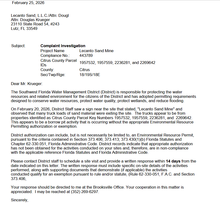
However, as part of that request on Friday, I received 100 pages of documents from SWFWMD that were sent to them by the owner of the site.
The documents present a history of the general area, not just this site. They cover a lot of the area that is not currently being mined and not currently owned by Lecanto Sand.
They raise far more questions than I had going into my article on Friday.
Going into Friday, I was ok with idea of them being allowed to mine the site without permits. It made sense.. non-conforming use or vested rights. I was fine with that and was going to report that and call it a day.
However, following the call I had with the owner Thursday, after I teased the article, I got a bit more curious. One thing I don't take kindly to is calling me in an "aggressive" manner like that. I am not a traditional journalist.. I wouldn't say I was one at all, however, I guess by definition, I have become one. The county now makes me go through the PIO with any questions, so I guess I have arrived to journalist status. I wonder if I can get that reserved seat behind the clerk's desk at the BOCC meetings... hmmm..
In any case, I do deep dives into issues and do my own research. As such, I do not find the need to call people with questions. On occasion I will reach out, but ask the Commissioners how often I ask them for a comment before writing something. Not very often.
You see, I do not need to do that. I do the research and report what the research shows. In this case, when the owner called, I mentioned not having an ERP from SWFWMD and he stated that SWFWMD was just on site and apparently all was good with them. He didn't mention to me anything about the letter they sent him weeks ago nor the email he sent earlier that day stating he would apply for the permits.
Interesting huh?
Doesn't take much to realize why I do not call people for their opinion before I run a story. I do not really care what they have to say... what do the documents and the evidence say? That is all the proof I need. I feel I am pretty intelligent and can piece it all together.
So calling me like that makes me want to do a deeper dive... and here we are. The entire weekend was spent gathering information for this. I do not get paid enough to do this.. hahaha.
Before we get started... a disclaimer... the owner is presumably operating as the county has allowed them to operate. I have not found anything to suggest that they one day decided to open a mine without the county knowing. The questions below are for the county in how they made that determination that this site does not need county permits or follow other LDC requirements. I question if the county got it right and if not, what can be done to correct it.
Time to see if we can get answers to these questions:
- Why are they allowed to mine without a county mining permit?
- Do they have vested rights or valid non-conforming use?
- Do they need to register with the county as a mine, as the LDC suggests? If so, have they done that? If not, why was that not required?
- What parcels are they allowed to mine or use as a borrow pit?
- Was there a variance issued on the lots to keep the 50ft setbacks as required in the 2009 letter?
Here we go.
To kick things off, here is a letter from 1984.

This states that lots 34, 35 and 36 had been used as a sand pit prior to 1979 and continuously to that 1984 date and as such, they are a valid non-conforming use and may continue as a sand pit.

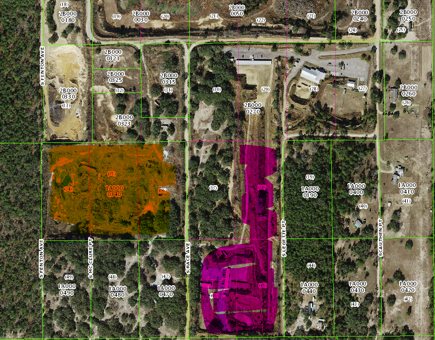
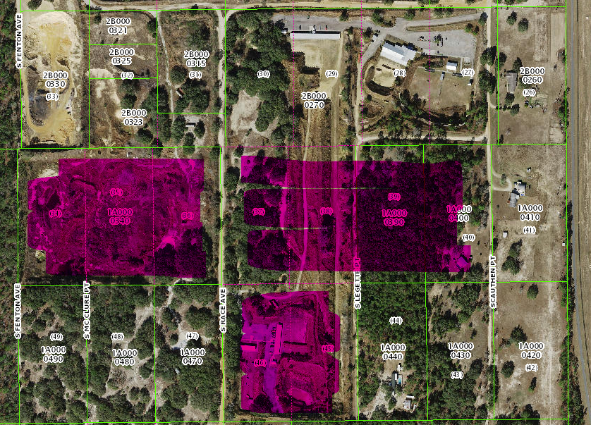
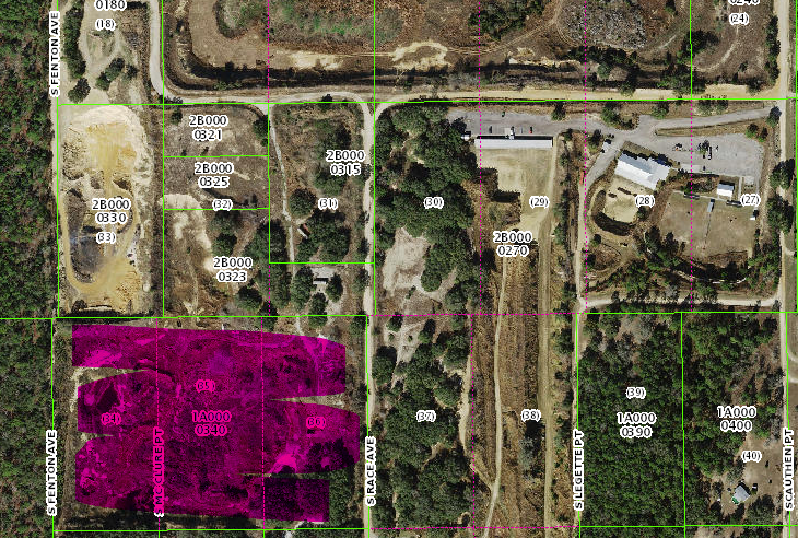
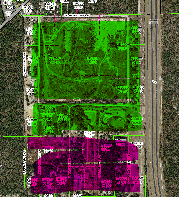
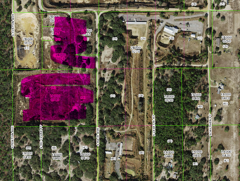
That is the pink area in the map above.
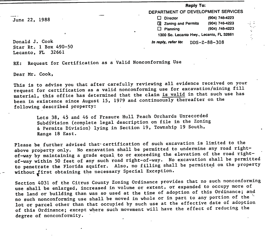
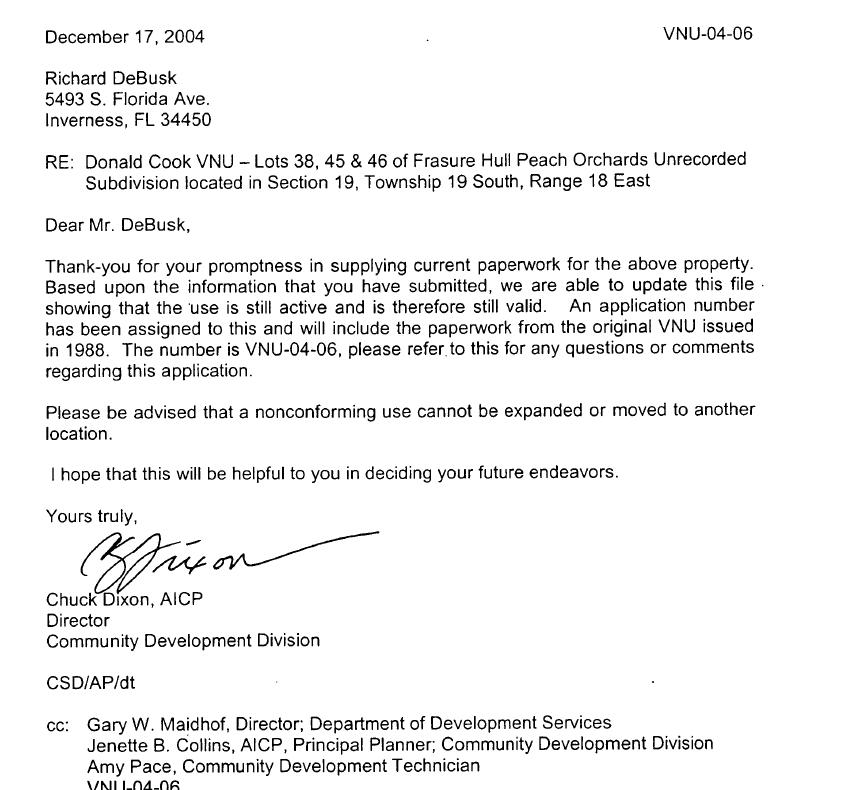
In 1988, someone also sought to get parcels 38, 45 and 46 approved as non-conforming use for mining. The county approved this.
The pink on the map below references these sites from the 1988 non-conforming use. The orange on the left are the previously approved non-conforming use, and part of the current site.
In 2004, these 3 parcels (pink above) were again approved by the county as non-conforming use, notably stating that the use was still active.
Now for some confusion... Surprise.
On October 21, 1993, the then Planning and Development Review Board recommended to staff that the PDRB initiate an applications for changing these lots from LDR to EXT on the future land use map. This would apply to lots 34-40 and lots 45 and 46. This would become BCC-CPA-94-03 at the BOCC hearing.
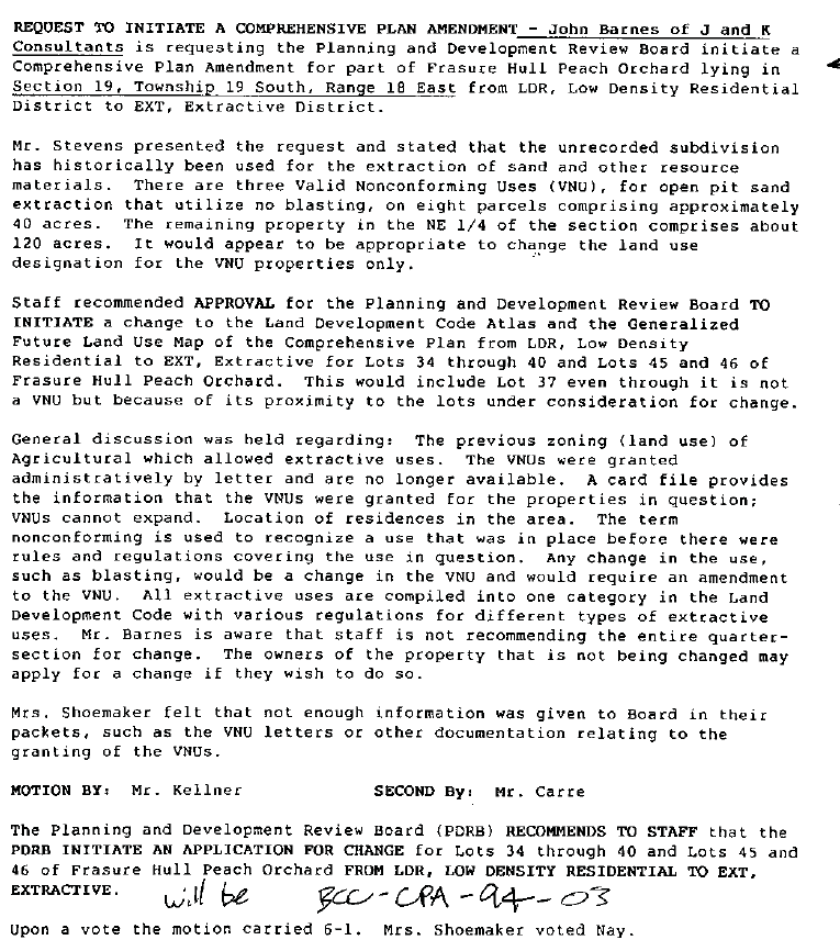
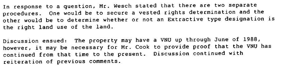
At the March 3, 1994, several opponents showed up to the meeting expressing concerns about the changes and stating that several of the lots have not seen continuous mining operations... which is required to keep the non-conforming use and vested use rights.
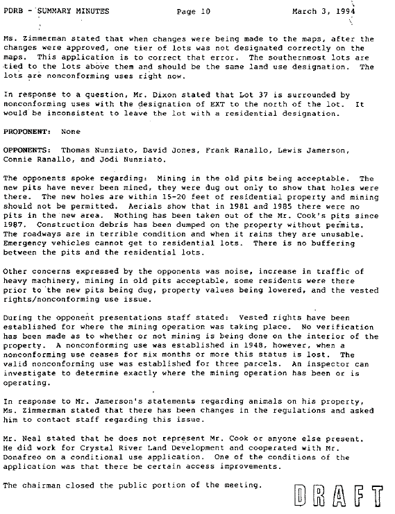
The record cuts off, so I do not know the result of that vote.. However, it came back on March 17, 1994 to the PDRB, so I presume whatever the vote was on March 3rd was not a final vote on the matter.
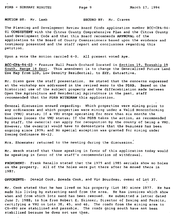
A key take away here. Staff recommended that the PDRB withdraw the application, due in part over questions of the non-conforming use.
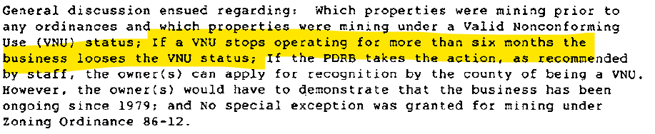
The owner would have to prove that the business has been operating continuously.
Here is the staff letter that accompanied the files for this hearing.
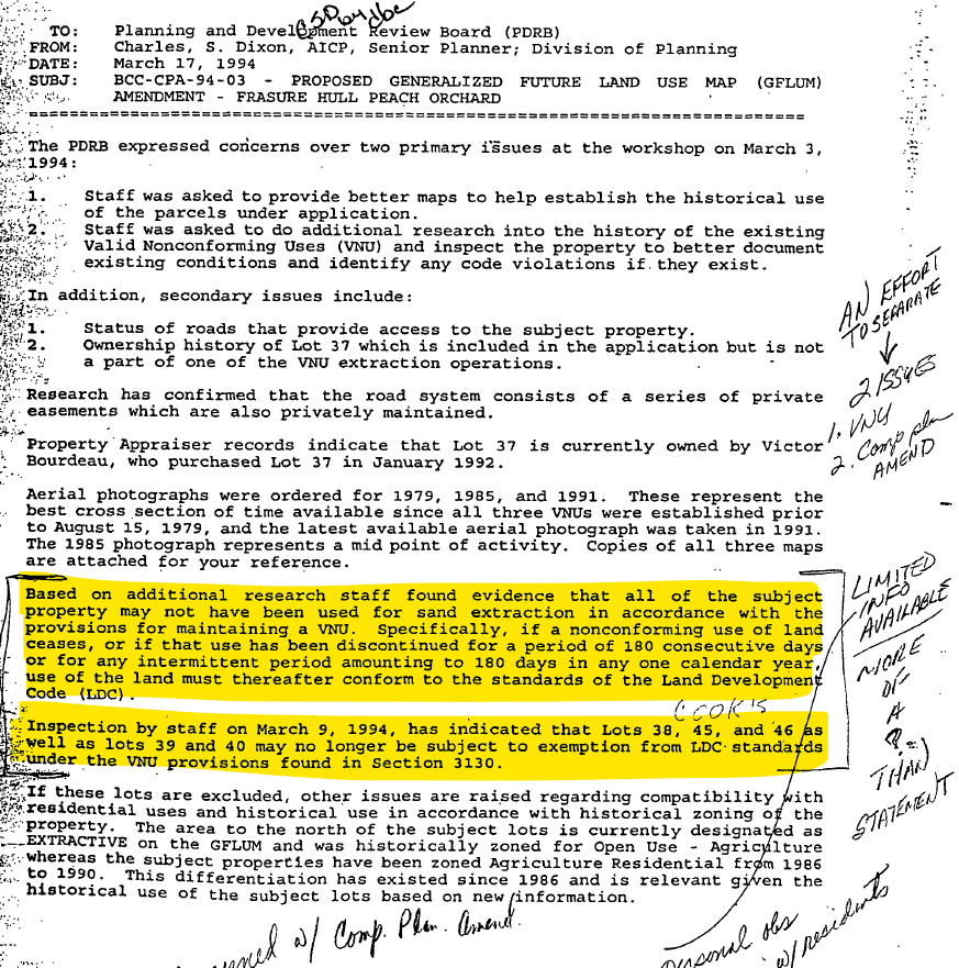
The yellow area shows that staff was concerned that the subject properties were not being continually mined, thus may not be protected by the non-forming use any longer and no longer exempt from LDC requirements. Notably, it did not include the parcels in use today... 34, 35, 36
The PDRB ended up voting to withdraw the application to change those lots from LDR to EXT on the future land use map.
On October 24, 2005, then Director of the Department of Development Services, Gary Maidhof, sent a letter regarding the sand pits.
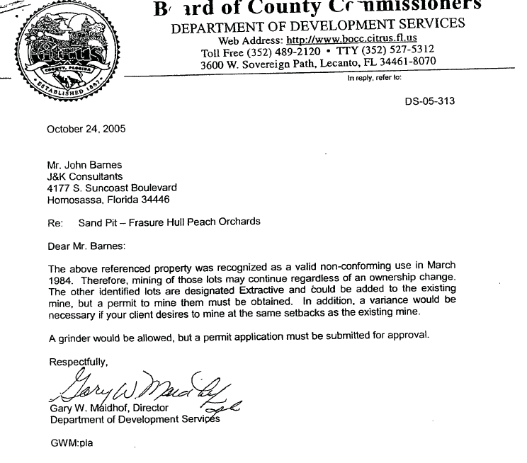
This letter references the 1984 letter we mentioned before, regarding lots 34, 35 and 36. The other lots referenced that are zoned extractive are lots 31 and 32. Maidhof says in the letter that they would need a permit to mine those and would need a variance if they wanted to keep the same setbacks.
Pink is the 1984 parcels with valid non-conforming use. 31 and 32 are just to the north of that. This is the first time the county has mentioned the need for a mining permit on any of these parcels. This letter encompasses the current site today.
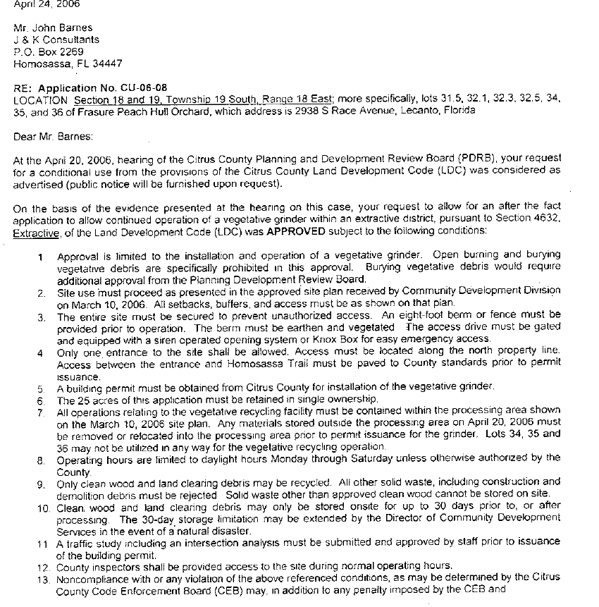
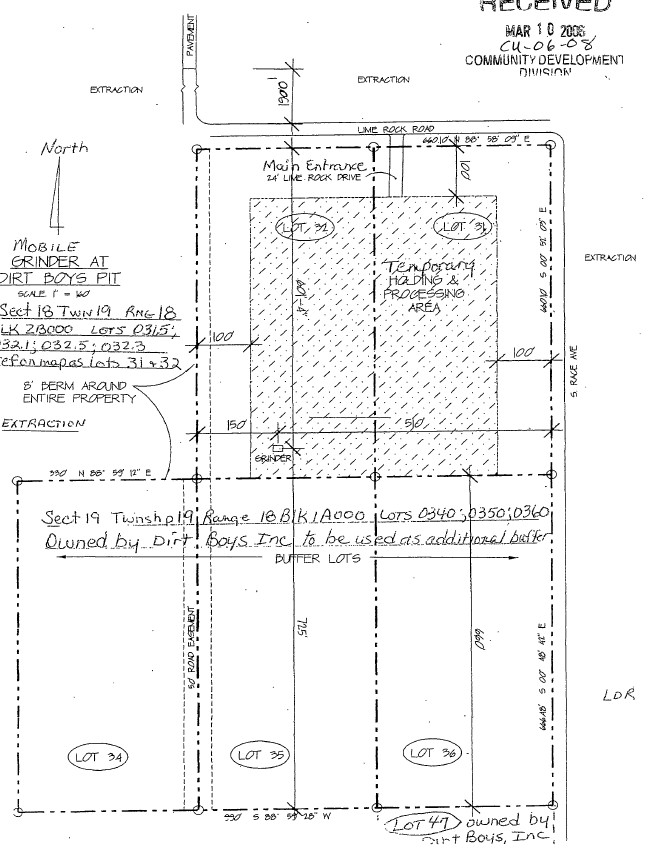
In April 2006, there was an application to get a vegetative grinder permit to presumably mulch vegetation. My understanding was they wanted to offer recycling of land clearing debris.
This was for parcels 31-36 (current site today).
Which is the site today that is currently being used as a borrow pit/sand mine.

This was approved by the county. However... they noted that the LDR lots are not to be used in any manner for the vegetative recycling operation. Those are the 3 lots on the south (34, 35, 36).
However, prior to that approval, was another application, CU-06-05 . This was to allow vegetative disposal in former sand pits around that area. In that, it references the 1988 and 1993 county decisions. From the staff report:
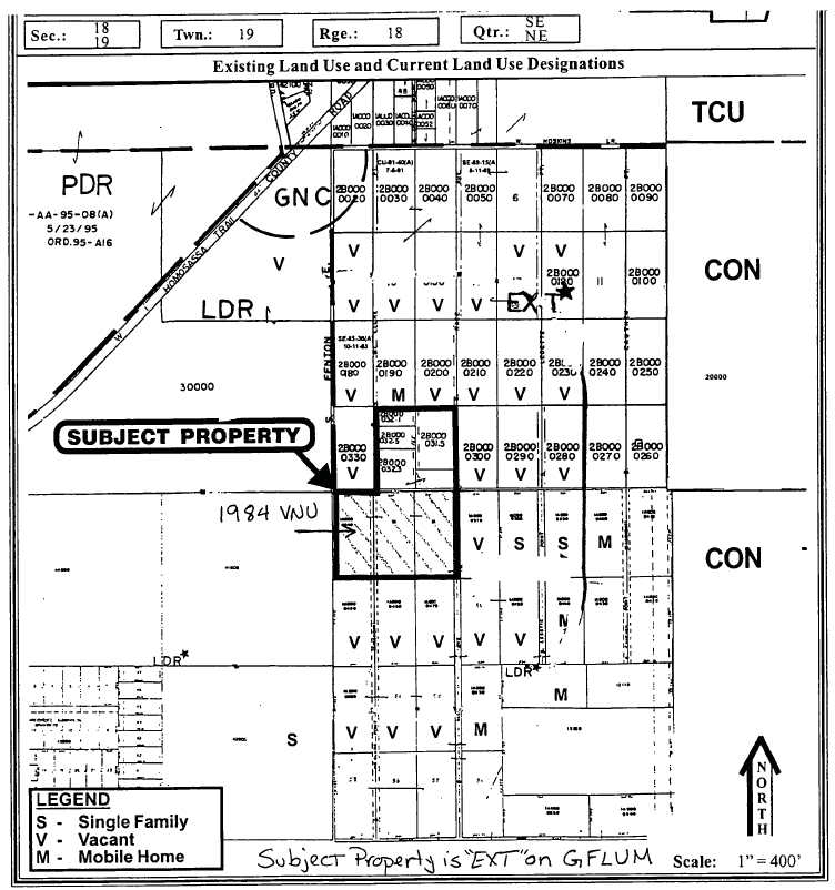
In this staff report, the county states that parcels 1-33 were designated Extractive, however, recognized that an application to change lots 34-59 was withdrawn by PDRB. Green is Extractive... Pink was denied extractive for future land use.
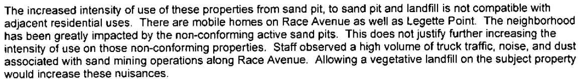
Further, in that February 22, 2006 staff report for this application, staff makes a bold statement.
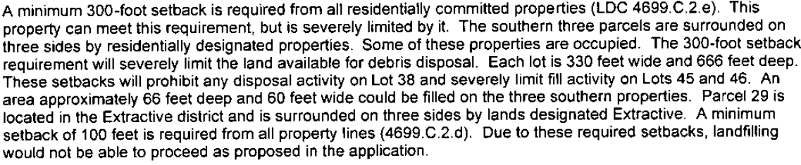
This report also references the setbacks for this landfill type use.
Staff recommended denial of this application, which is why I think they asked for the vegetive grinder under application CU-06-08.
Fast Forward to March 5, 2007. A letter send from then Public Safety Director, Charles Poliseno, to then County Administrator June Fisher, stated that this chipper/grinder was in violation of the conditional use. Dirt Boys ended up removing it.
Notably, this letter states that they have a valid non-conforming use for the mining on that property from 1988 (parcels 34, 35 and 36). Again, this is the parcel. The small section to the north in pink, that is extractive today.
Jump ahead to February 4, 2009. Maidhof sends a letter to Dirt Boys.
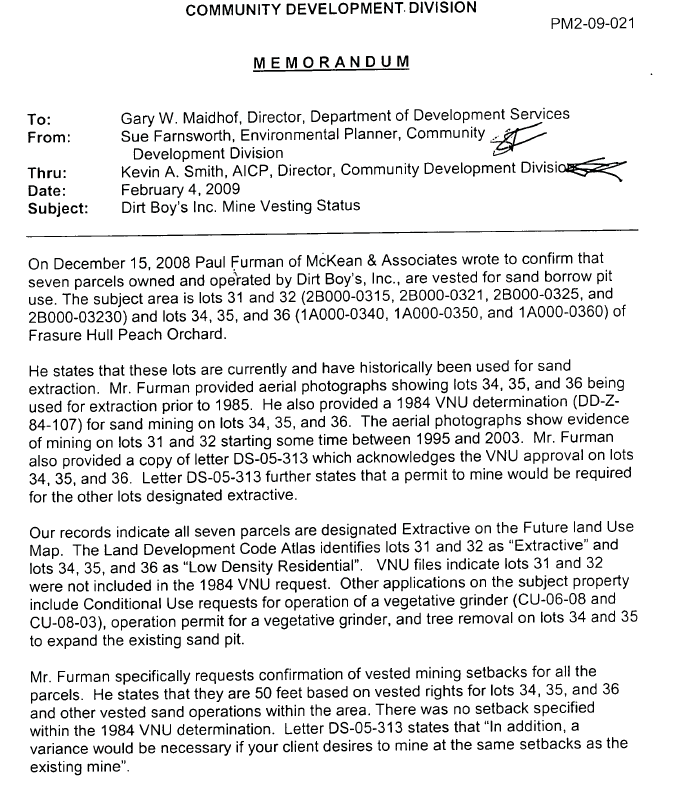
He includes this map and references the 1984 letter and his 2005 letter.
This letter was in response to a letter sent to his office by Paul Furman in December 2008 (I do not have this letter yet) seeking clarification on vested rights for a sand/borrow pit.
This is talking about the lots that are currently being used as the borrow pit/mine... lots 31, 32, 34, 35 and 36.
Specifically he states that lots 31 and 32 WERE NOT included in the valid non-conforming use in the 1984 request. The letter reiterates the need for the need for a variance for the setbacks of 50 feet.
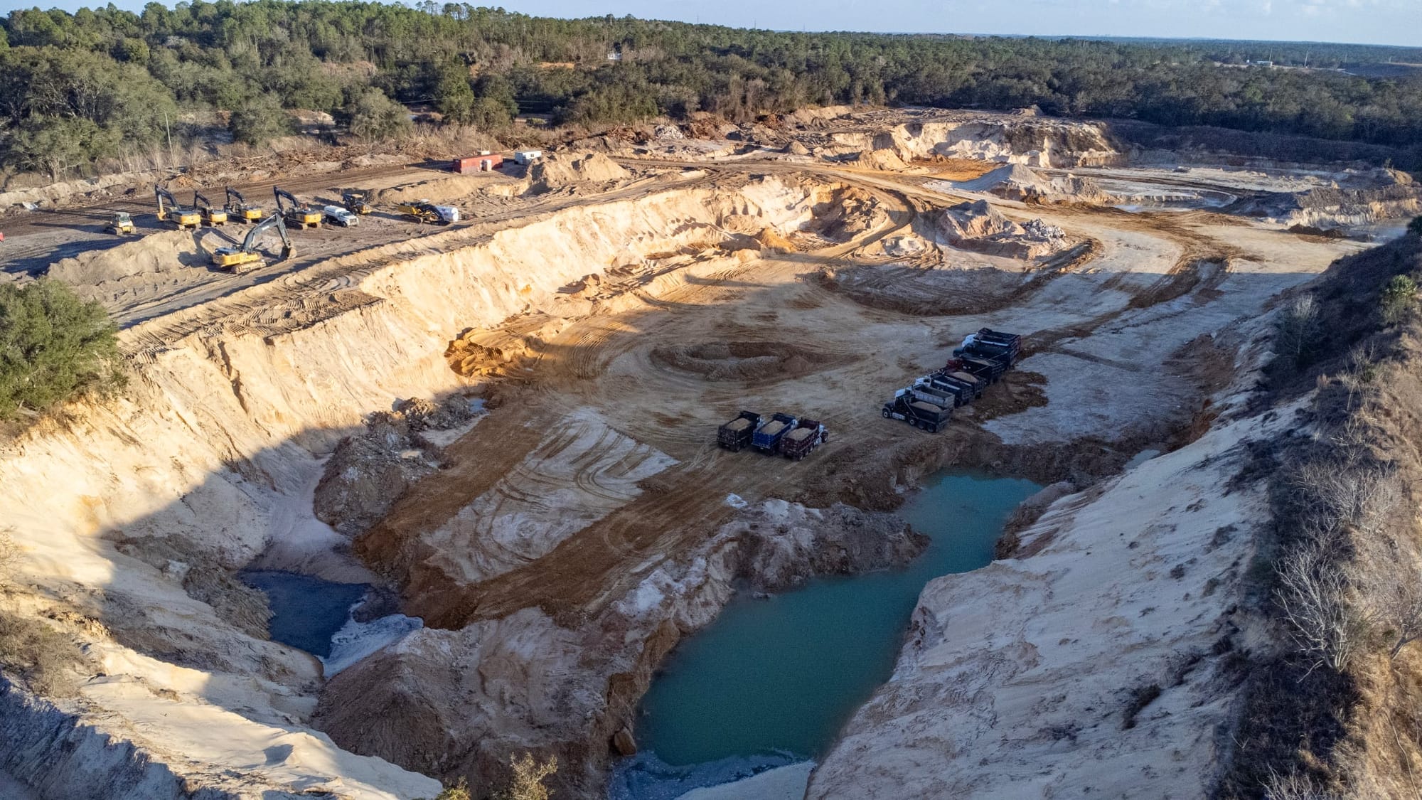
This would suggest that the northern lots, the ones with the trucks in this image below, ARE NOT part of the valid non-conforming use parcels, meaning that they would need a mining permit to be able to mine those sites.
When I did a records request for mining permits, the county said none exist.. and that went back through early 2000s, because I received the vegetative grinder approval from 2006.
Since Maidhof sent his letter to Dirt Boys in 2009, no mining permits have been pulled/issued, despite him stating that they were needed for those two lots at the north as they were NOT part of the valid non-conforming use.
Phew, that is a lot of history for this site.
Now.. the questions for the county.
Chapter 10 of the Land Development Code addresses Non-Conforming Use. Here is the purpose.
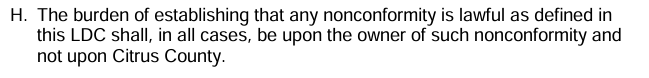
Importantly, the burden is on the owner to prove that the non-conforming use exists and is NOT on the county to prove it.
Now the key to all of this. Section 10170: DISCONTINUANCE, TERMINATION, OR ABANDONMENT
If a nonconforming structure or land ceases (if the building becomes vacant or the business closes), or if that use has been discontinued for a period of 365 days (one year), use of the structure or the structure and land shall thereafter conform to the standards of this LDC....
In other words, they have to continue to use the land in the manner that they had used it for the non-conforming use. In this instance, as a sand/borrow pit. They cannot go more than one year without that use, otherwise, they lose the non-conforming use designation and have to follow all current LDC requirements for mine sites.
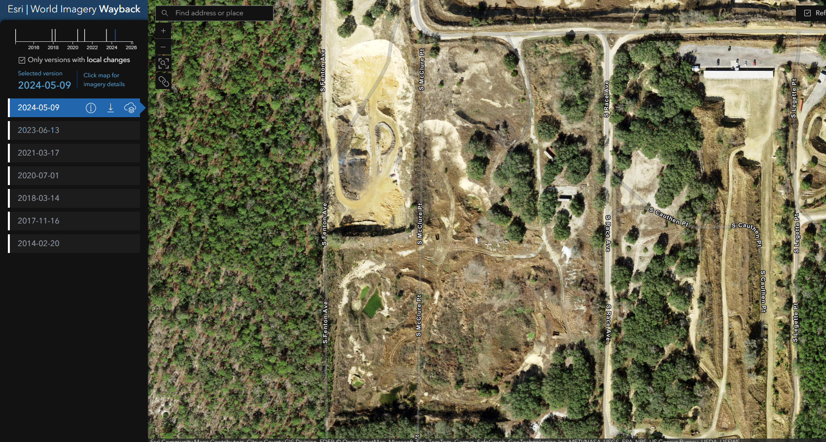
Now, satellite images come in handy.
Here is the site on February 20, 2014. Remember, based on that 2009 letter from Maidhof, only lots 34, 35 and 36 qualify for the non-conforming use of a sand pit/mine. Lot 31 and 32 would need a mining permit despite extractive zoning.
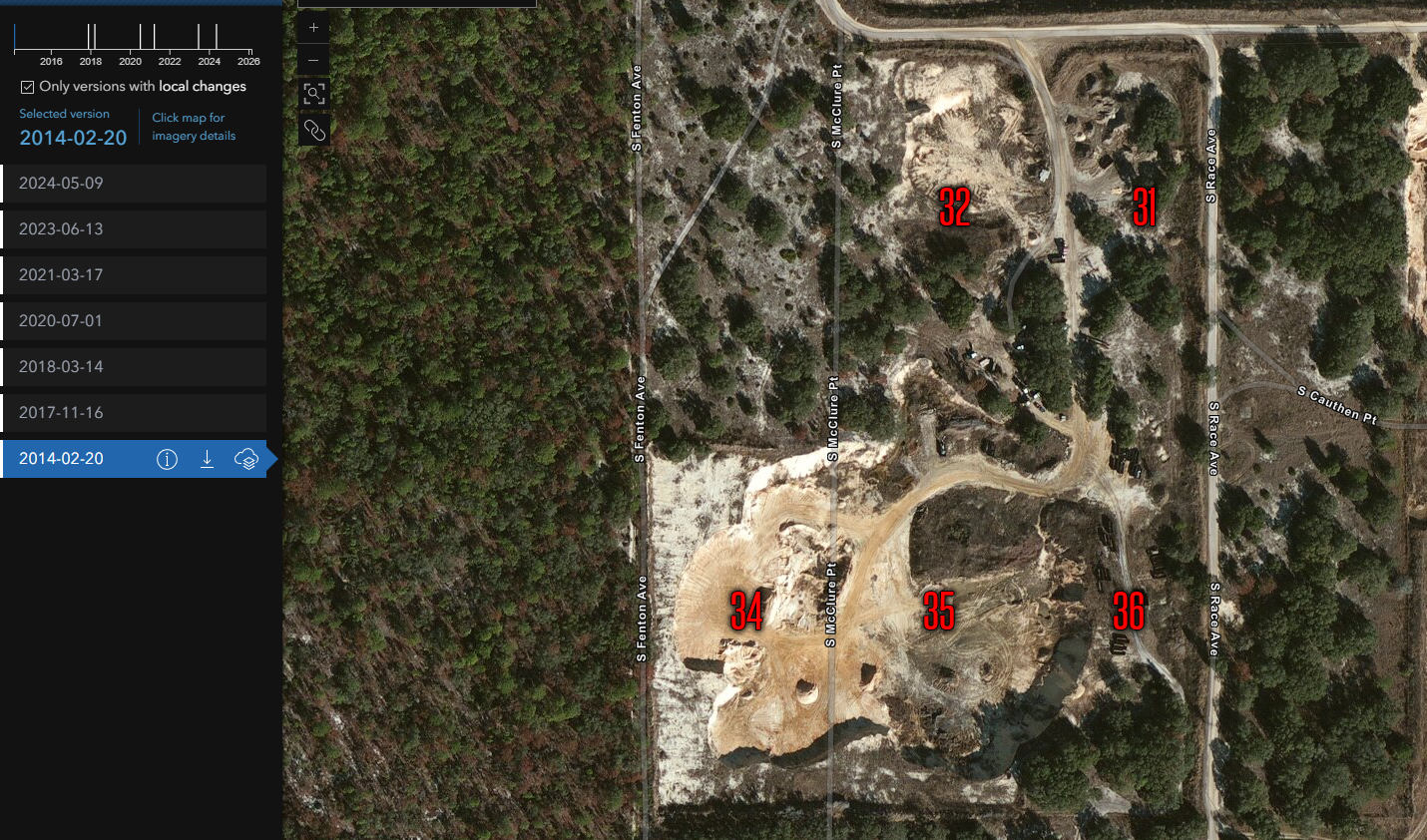
As you can see, in February 2014, the southern portion appears to be a mine site. All good here.
Here is November 16, 2017. I still see trucks in that southern section. Seems active to me.
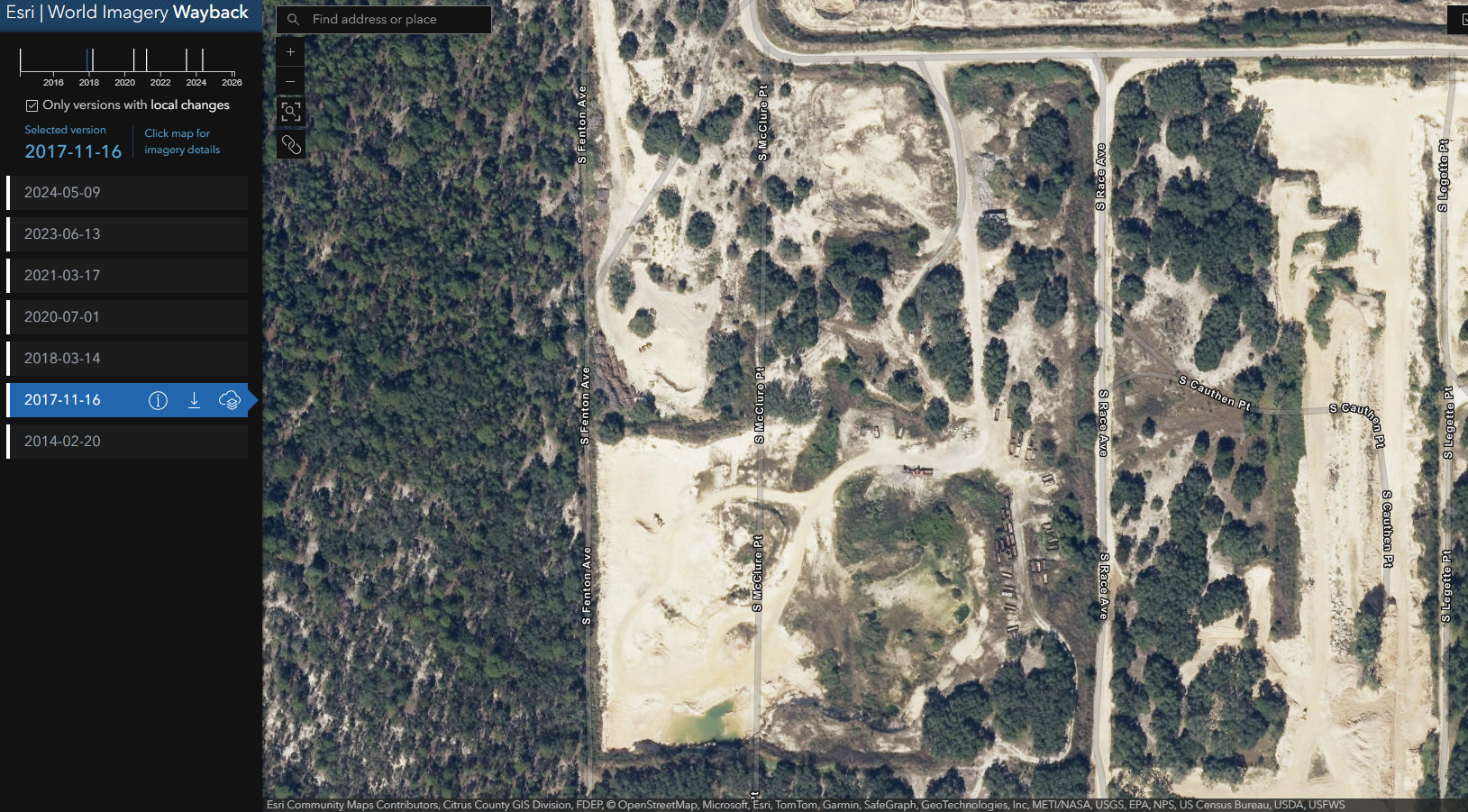
March 14, 2018. Still appears to be active on the southern portion. I notice a bit of clearing on lot 32 that did not exist before.
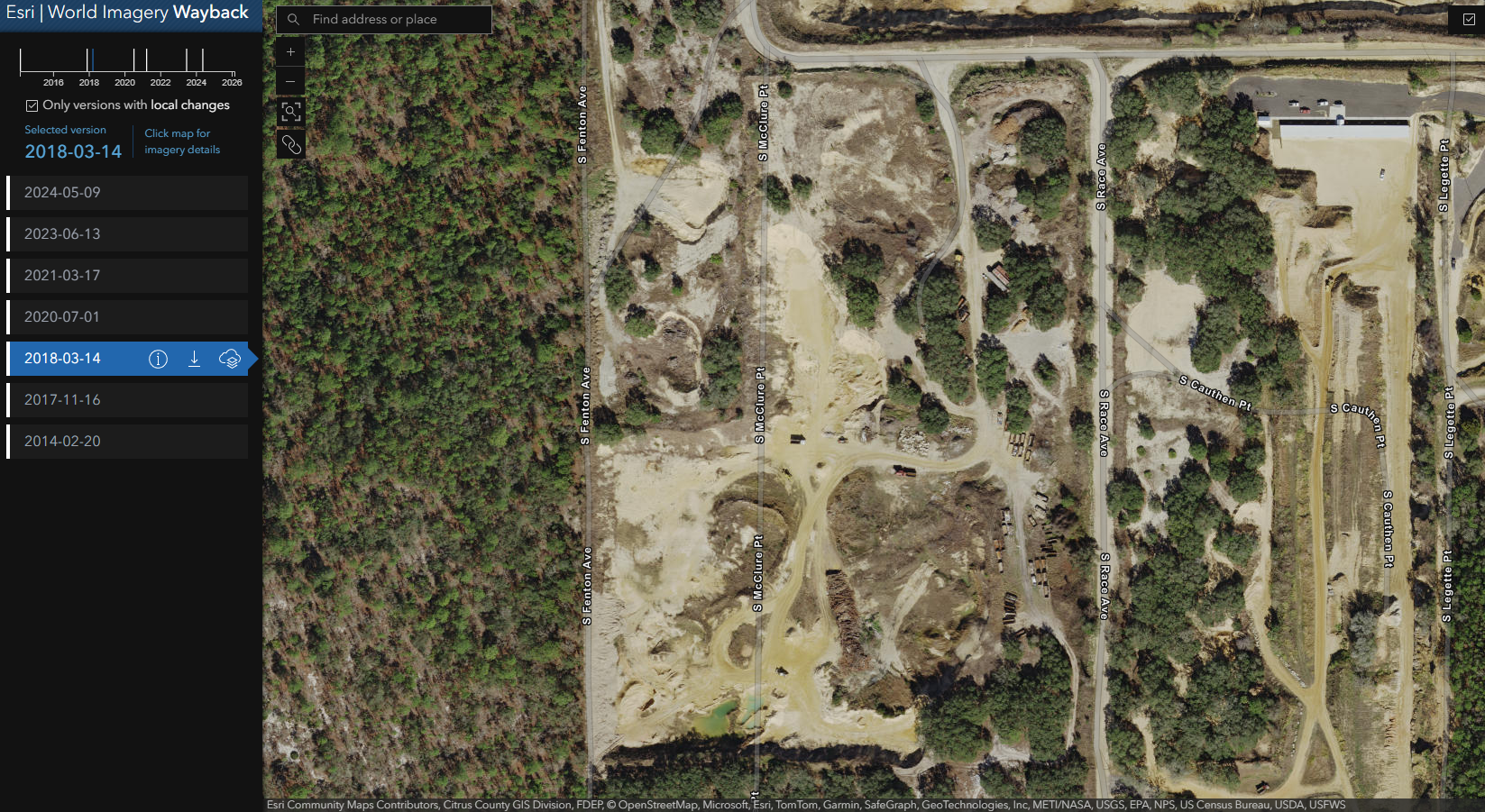
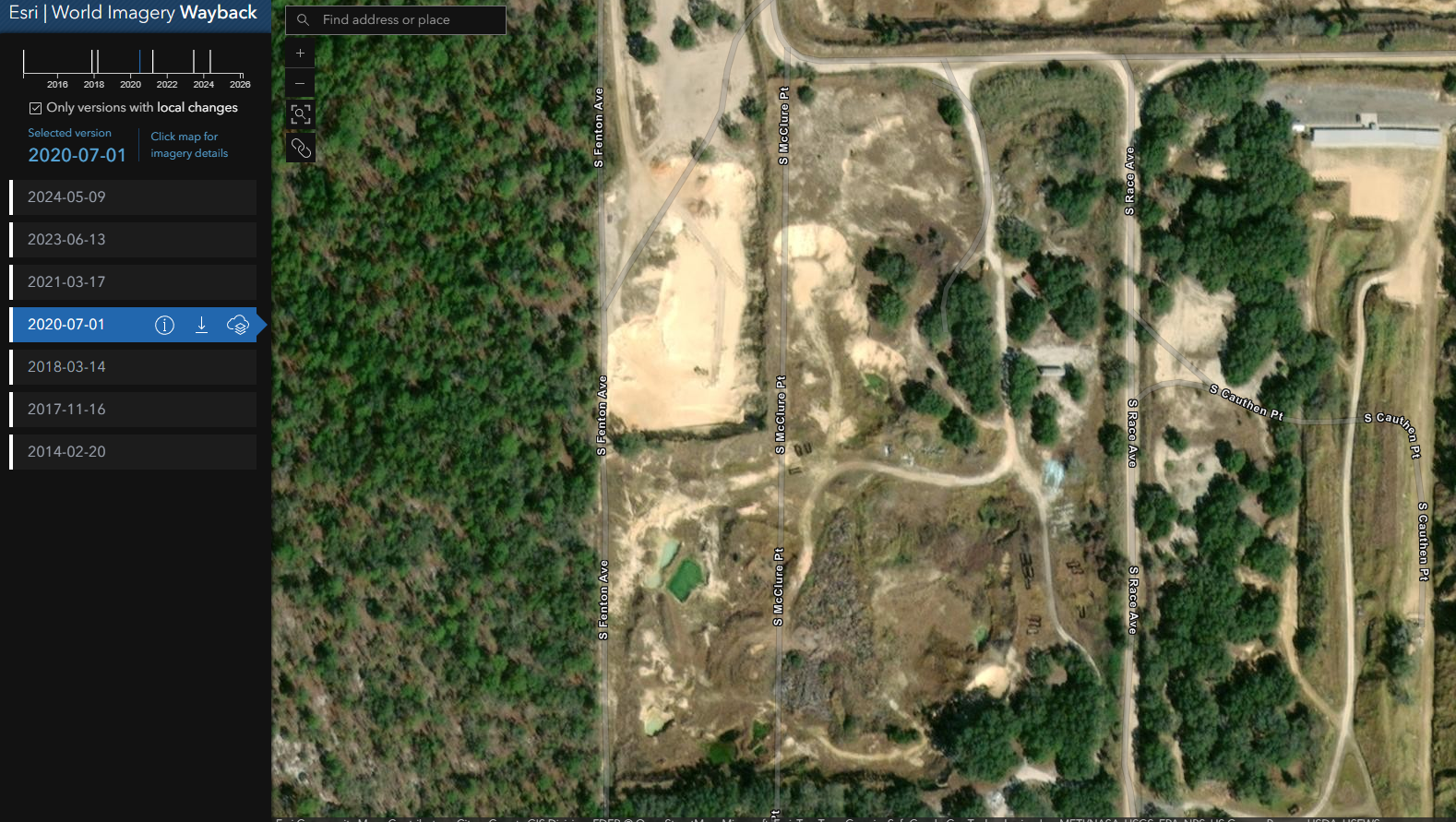
July 1, 2020. Big change over these 2 years. The site no longer appears to be used. There are a few roll-off dumpsters it looks like and a few trailers on the road on lot 31, but no active site from appearances.
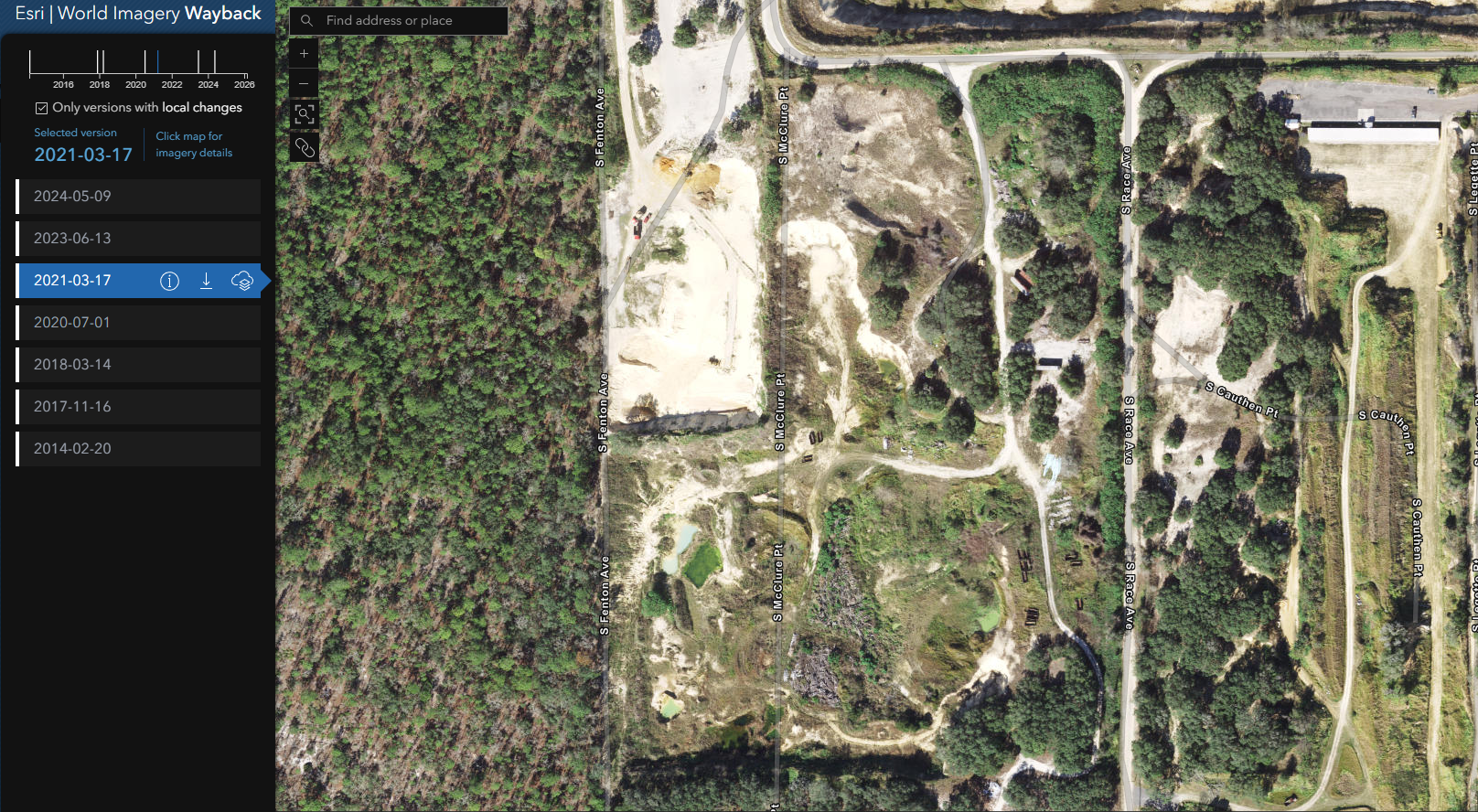
March 17, 2021. Still appears to not be an active site. Greenery is getting more pronounced and the "trails" the trucks used are getting overgrown.
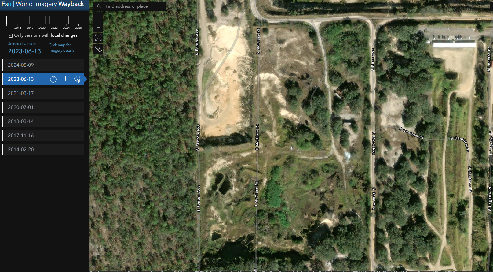
June 13, 2023. Same as before. No mining/sand put usage. The site is more overgrown and more bushes or small trees are beginning to appear on those bottom lots.
May 9, 2024. Still no use on the land that I can see... certainly no mining/sand pit activities. We do see the parcels to the west being used as a sand pit and clearly showing what an active site looks like. Lots 31, 32, 34, 35 and 36 do not show that use.
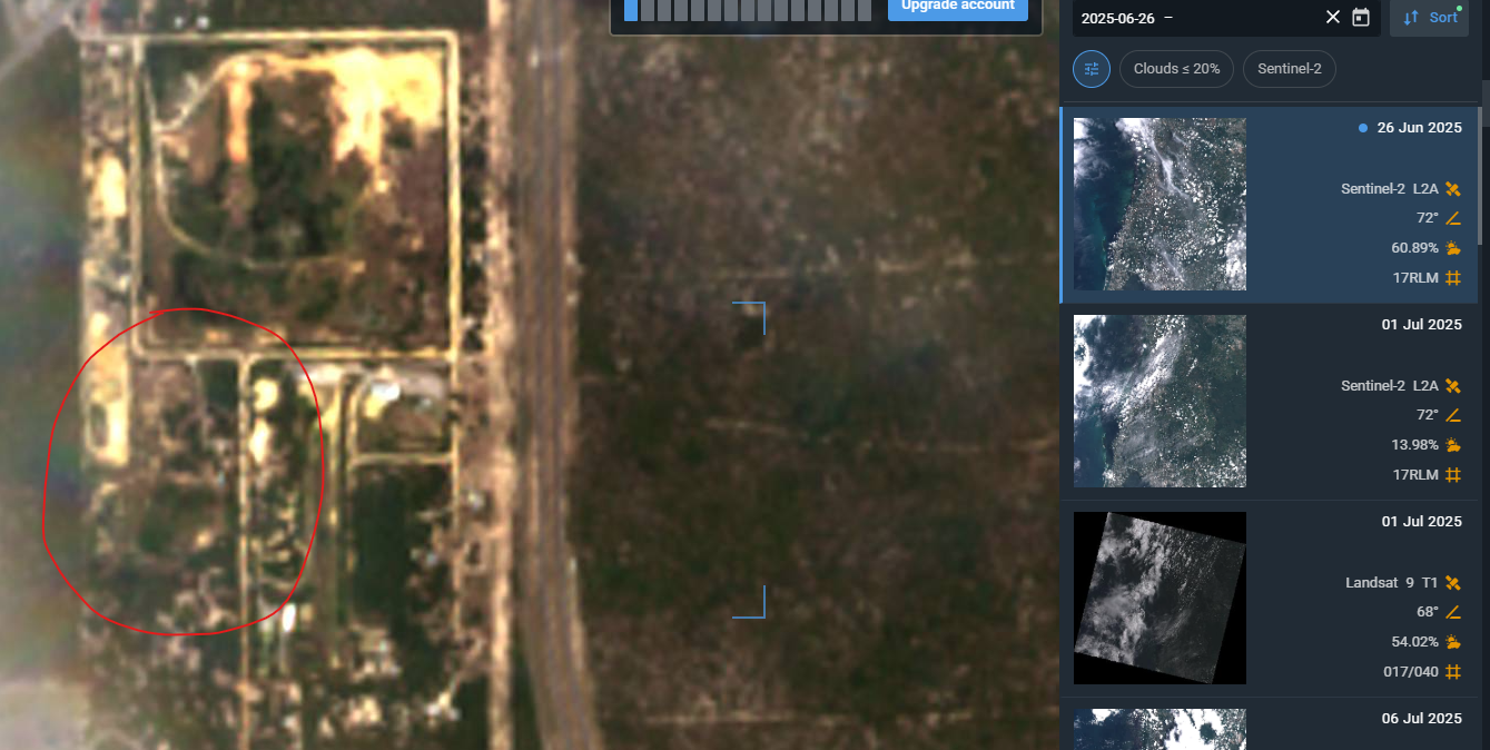
June 26, 2025. This is 2 days after Lecanto Sand purchased the site from Dirt Boys. ZERO mining activity is seen on this image. It is overgrown.
September 19, 2025. We see that parcels 31 and 32 are beginning to be cleared. This is the first activity on these parcels since 2018/2019.
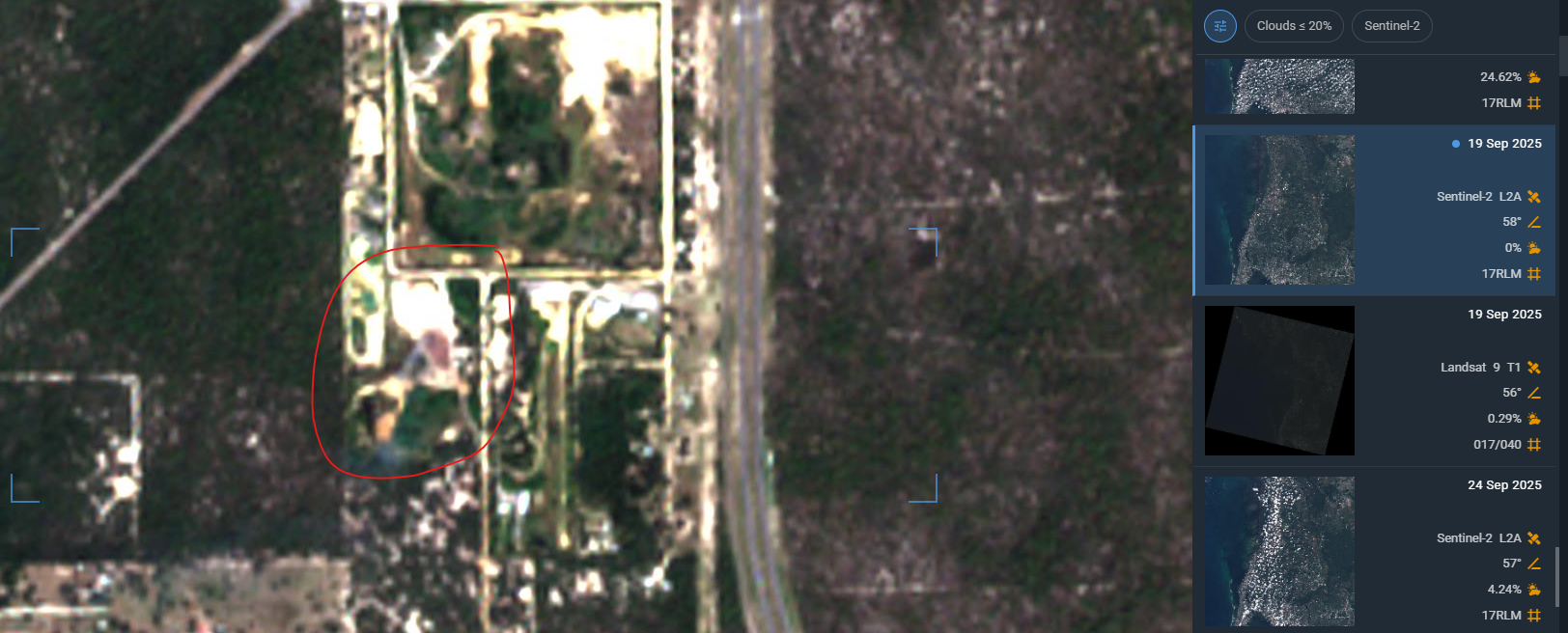
Over 5 years have gone by since any use has been recorded on the site in which they had the prior non-conforming use approval for. Per the LDC, that means the parcels would lose their valid non-conforming use for not being used for over 365 days. Accordingly, this would appear to suggest that they would need to apply for permits and follow the current LDC requirements.
So the question to the county... Is this still a valid non-conforming use? If so, where is the documentation stating that the non-conforming use was approved/extended despite clear proof of no mining operations?
Remember, the burden is on the land owner to prove that there was continuous use of the property for the purpose of the non-conforming use. They would need to show receipts for revenue generated from that site or some other type of proof that they had continuously used that site... or proof from the prior owner (Dirt Boys) in this case since Lecanto Sand purchased the property in 2025.
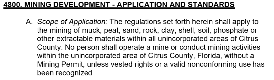
Question #2... In Chapter 4 of the LDC, under "Mining Development"
Under the vested rights section.
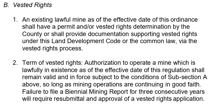
What documentation has been provided to the county to show the vested rights that exist to mine this site? Remember, the 2009 letter stated the owners did not have rights to mine parcels 31 and 32, when they asked about vested rights... that appears to be where the mining is taking place today.
So where is the documentation for this?
Again, this is on the owner to prove vested rights, not the county. Further #2 above, the vested rights only apply if they continue to use the property in good faith. The property does not appear to have been used for at least 5 years, and these two parcels (31 and 32) never appeared to have been mined in the past, at least since 2009.
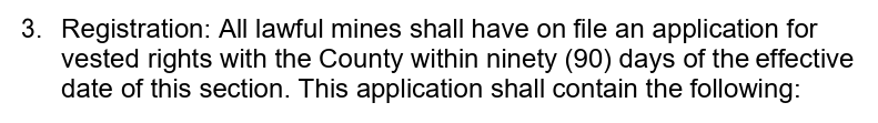
What about the Biennial Mining Report? Have those been submitted to the county, as required?
If no, that would suggest a requirement to comply with current LDC requirements and the requirement to get a mining permit... one that the county says does not exist.
Further... #3 requires mines with vested rights to register. Where are the registration files... specifically section D... the SWFWMD permits.
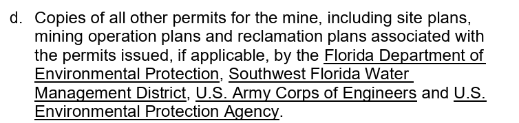
This requires vested rights mines to have all the permits as part of the registration. I showed the letter from SWFWMD stating that there was no ERP permit and that the owner would work on getting one. They are also required to include an aerial map of the mining site... a site plan essentially.
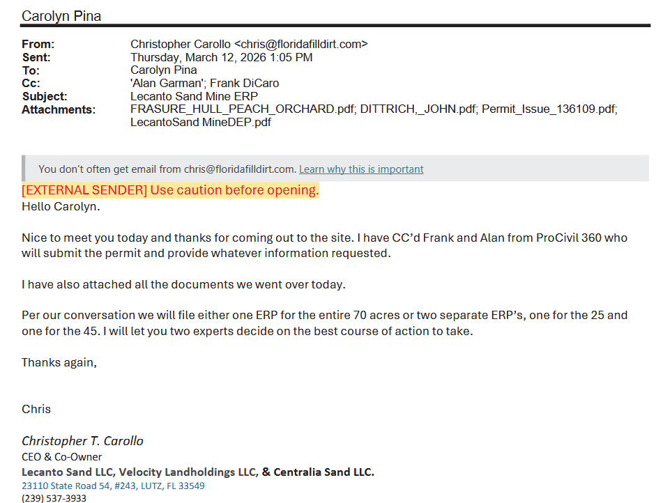
The owner did file for a permit from DEP in December 2025.
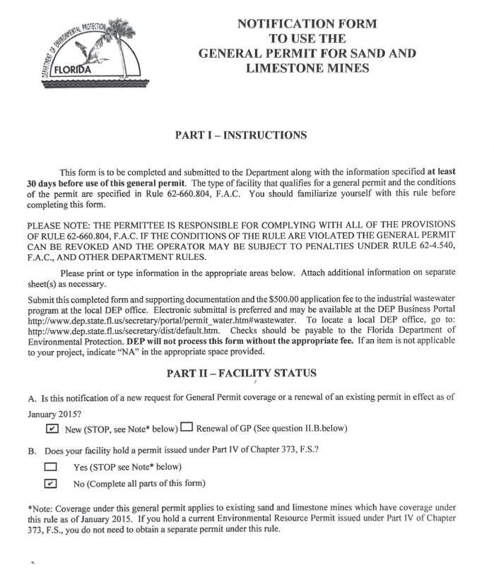
Then there is this.
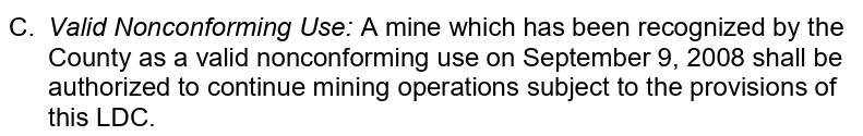
There you go... failing to register would mean they have to follow current LDC provisions.
Did they register for a vested mine site? Did the county waive the registration requirement for this site? Are they claiming they are operating as a vested mine?
Perhaps they are not operating as a vested mine site and are operating under a valid non-conforming use... as the site had done in early 2000's.
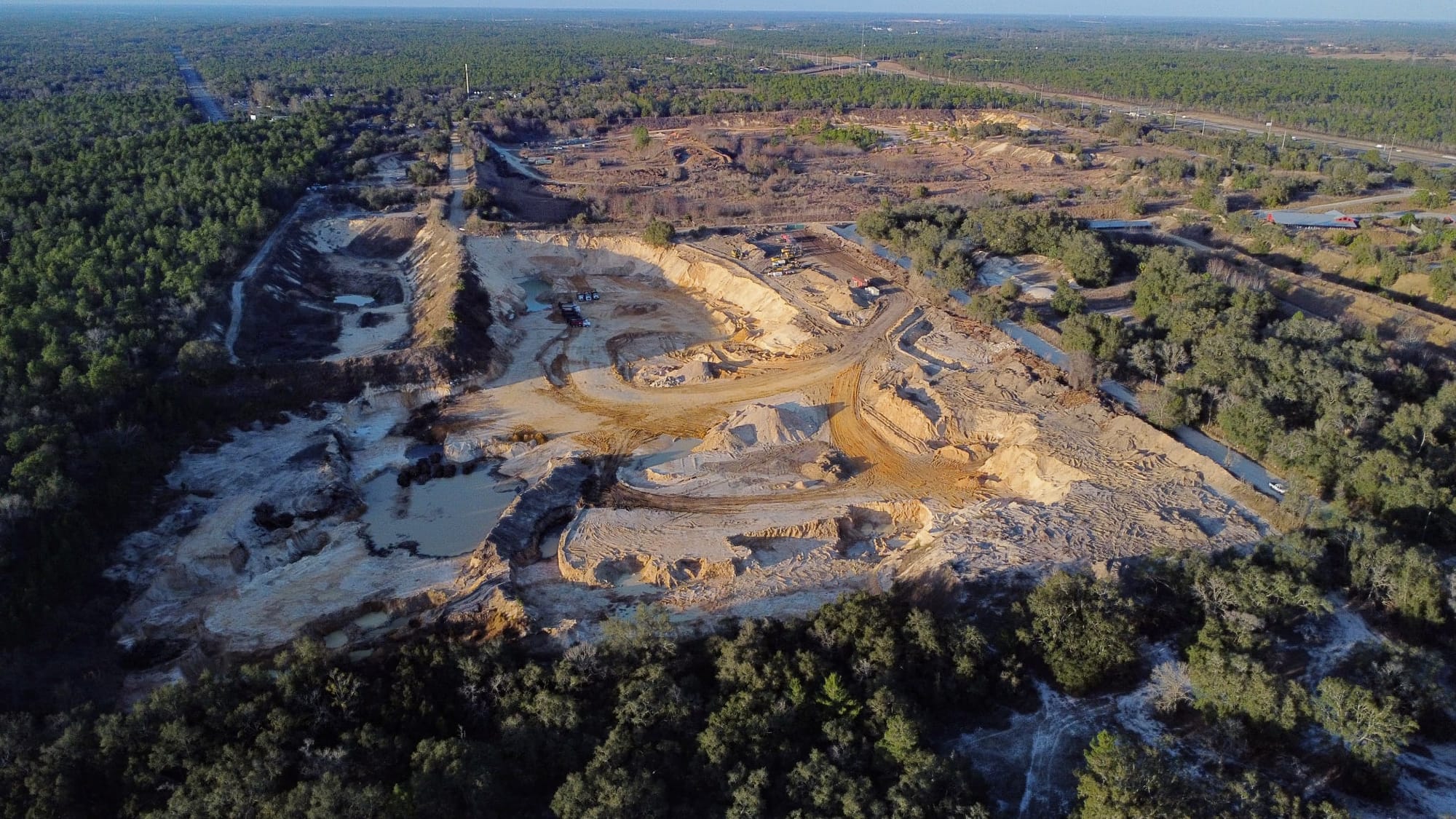
Now, here is where things get sticky. If the argument is that they have valid non-conforming use as of September 9, 2008, this clause suggests they can continue mining operations.
The parcels 34, 35 and 36 have been recognized as valid non-conforming use prior to 2008 per the provided letters. That is the bottom rectangle in this picture.
Assuming the county ignores the LDC requirement to maintain the mining use and ignores the gaps in use over the years, it would appear that these parcels would be allowed to be used for a borrow pit.
But remember, parcels 31 and 32 were NOT included in that valid non-conforming use in anything that I can find. It appears that those parcels would be required to get a mining permit and that is where the mining appears to be taking place today.
I see nothing that suggests that parcels 31 and 32 were included in the non-conforming use prior to 2008.
Are they allowed to mine on those two parcels? Where does that county stand on that?
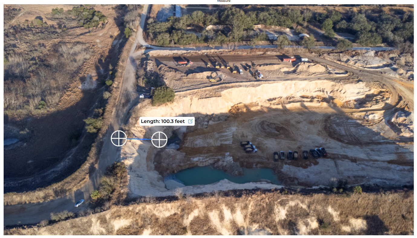
What about the variance for 50ft setbacks? Based on my measurement on google maps, the setback from the road to the opening of the pit on parcel 31 is approximately 45 feet. Let's call it 50 feet for the sake of argument and inaccuracy of this measuring method.
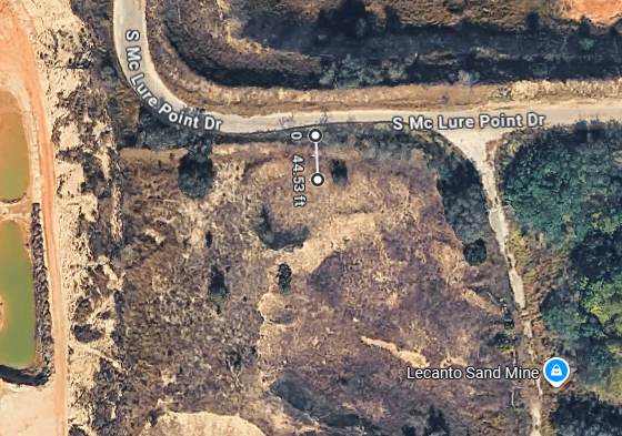
That 2009 letter from the county stated that in order to keep the 50ft setback across the sites, they needed to apply for a variance. I believe the current LDC requires a 100ft setback for mining operations.
Has there been a variance issued to allow a 50ft setback? Doesn't that require the BOCC to approve it? I do not think that staff can simply sign off on a variance for that. I do not recall this project coming before the BOCC for approval of a 50ft variance, at least not since Lecanto Boys took ownership. But perhaps staff can approve it.
Did they do that here? If not, I would presume they need 100ft setback and this site certainly does not have that. It is approximately 100ft from the road to the bottom of the mining pit. My understanding, which could be wrong, is that the setback would be from the start of the property line to the start of the activity, in this case, the beginning of the dig site, which would be up the bank further towards the road, not the bottom of the pit.
As you can see, this is pretty complicated. I am seeking answers to these questions and will do another article once I get these answers. Stay tuned.